


“India’s Seven States… the eastern part of the country… known as the Seven Sisters, are landlocked regions. They have no access to the sea. We are the sole maritime guardian for this entire region, which opens the door to immense possibilities.“
This statement made by Mohammad Yunus, Chief Advisor to the interim government of Bangladesh, during his visit to China, highlights India’s strategic sensitivities and the geographic constraints of the northeastern states.
Recognizing this geopolitical weakness and taking a strategic step in this direction, India, under the chairmanship of Prime Minister Narendra Modi, approved the development of the Shillong-Silchar Corridor in the northeast with a total investment of ₹22,864 crore through the Cabinet Committee on Economic Affairs on 30 April.
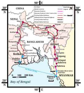
This ambitious future corridor will span 166.80 km as a greenfield high-speed corridor from Mawlyngkhung in Meghalaya to Panchgram in Assam under a Hybrid Annuity Mode (which involves both public and private funding). The project includes the construction of 19 major bridges, 153 minor bridges, 326 culverts, 22 underpasses, 26 overpasses, and 34 viaducts. Out of the total length, 144.80 km will be in Meghalaya and 22 km in Assam.
If we look at this corridor in isolation, it may seem like just another attempt to improve intra-regional connectivity in the northeastern states. However, when viewed in conjunction with the India-Myanmar Kaladan Project, its full strategic importance becomes clear. On one hand, the Shillong-Silchar Corridor connects most of Meghalaya and reaches Silchar in Assam. On the other, the Kaladan Project connects the Sittwe Port in Myanmar’s Rakhine State to Paletwa via the Kaladan River, and from there by road to Zorinpui in Mizoram. Therefore, developing a new highway from Zorinpui to Silchar would integrate both projects and effectively link the entire northeast region to the sea.
Now the question arises: why is such an effort necessary?
For a long time, Bangladesh has been considered, if not essential, then certainly the most convenient route to connect the northeast to the Bay of Bengal. This is due to Bangladesh’s geographical location. It lies between India’s northeast and the Bay of Bengal, and shares a 4,096.7 km-long international border with India — the fifth longest in the world, with 1,879 km adjoining the northeastern states of Assam, Tripura, Meghalaya, and Mizoram.
Any observer of this geographical reality would agree that Chattogram and Mongla in Bangladesh are the nearest and most convenient maritime outlets for India’s northeastern states. This has also been the case over the past 15 years — thanks to the friendly relations between India and Sheikh Hasina’s government in Bangladesh, several agreements have allowed India’s northeastern states, and even Bhutan and Nepal, to benefit from this access.
However, recent political changes in Bangladesh and several developments over the past few months have strained India-Bangladesh relations. Notably, Bangladesh’s decision to allegedly invite Chinese investment for an airbase near the strategically sensitive Siliguri Corridor (Chicken’s Neck) in Lalmonirhat has compelled the Indian government to look for alternative routes. This is precisely why such an effort has become critical for India.
Now let us explore the role of this corridor in regional development.
To answer this, we must consider two perspectives: local and India-China.
At the local level, the construction of this corridor will significantly improve connectivity between Meghalaya and Assam. This will spur economic growth, boost tourism, and reduce both travel time and distance. The corridor will pass through Meghalaya’s cement and coal production zones, which will support these industries and accelerate regional development. In this way, the corridor fulfills regional development even at the most local level.
Shillong-Silchar is significant as Silchar is the entry point for connecting Mizoram, Tripura and Manipur as well as the Barak Valley region of Assam. Thus, it will become a major connectivity link for the entire North-East and an important milestone for developing the region as a gateway for India’s Act East Policy.
With the help of the Kaladan project, cargo will reach from Vizag and Kolkata to the North-East, without being dependent on Bangladesh. The high speed-corridor will ensure transportation of goods via road after that, which will spur economic activity in the region.
Now, in the context of India-China relations, this entire effort was triggered by China’s growing infrastructural footprint in neighboring countries. India’s northeast, particularly the Siliguri Corridor and Arunachal Pradesh, has seen growing strategic pressure from China. In response, India has pursued alternative connectivity strategies in the region. This includes the India-Myanmar-Thailand (IMT) Trilateral Highway to connect with Southeast Asia via Myanmar and the Kaladan Multi-Modal Transit Transport Project to link India’s eastern ports — particularly Kolkata — with the northeast.
By strengthening ties with Myanmar through such infrastructure collaborations, India aims to counter China’s expanding regional influence, especially through projects like the China-Myanmar Economic Corridor (CMEC).
But what about the success or failure of these infrastructure diplomacy initiatives?
In an ideal scenario, if viewed on a map, the integration of the Shillong-Silchar Corridor with the Kaladan Project would enable India to achieve its desired strategic outcomes.
However, as the saying goes, “There is no ideal situation in international diplomacy.” This holds true for India as well. The Shillong-Silchar Corridor is an internal development project and is likely to be completed. However, it will not achieve its full strategic objective unless the Kaladan Project becomes fully operational. The biggest hurdle in the Kaladan Project’s completion is the ongoing conflict between the military and rebel groups in Myanmar, particularly in Rakhine State — through which the road segment of the project must pass and which is currently under rebel control.
Although India’s Ministry of External Affairs is reportedly engaging in backchannel negotiations with these rebel groups, there is hope that work might soon resume. If that happens, by the time the Shillong-Silchar Corridor is completed around 2030, an integrated route to Sittwe Port may also be in place.
In conclusion, this initiative not only addresses India’s emerging geo-political challenges, but also places the northeast at the center of India’s Act East Policy and its wider Indo-Pacific ambitions.
Discover more from Politics by RK: Ultimate Polity Guide for UPSC and Civil Services
Subscribe to get the latest posts sent to your email.
